Louisiana sunsets in the snow ?️❄️? pic.twitter.com/4AGy3tYo7O
— sid? (@eggsidney) January 22, 2025
ARCTIC OUTBREAKS
https://sites.krieger.jhu.edu/waugh/research/polarvortex
https://bostonglobe.com/new-england-weather-cold-snap-arctic-air
by Ken Mahan / January 22, 2025
“The country is in the clutches of the coldest air of the season with more than 40 states, including Massachusetts, seeing cold weather alerts at some point this week. Nearly every state from Texas to Maine, including sunny Florida, continues to feel this Arctic blast, dropping temperatures as low as 30 to 40 degrees below normal for some locations. Unlike in February 2023 when polar vortex slipped New England into a deep freeze, this rush of cold air has certainly been influenced by the vortex but it’s not the main culprit.
The United States is underneath the most unusually cold blob of air on the entire planet on Tuesday. pic.twitter.com/ea8JydW1lH
— Ben Noll (@BenNollWeather) January 21, 2025
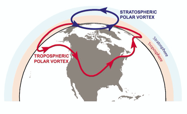
A massive dome of high pressure — virtually a mass of sinking air — already sitting above central Canada pulled a sliver of the chilled polar vortex into the United States late last weekend. That surge of frigid air exacerbated already cold temperatures in the Northeast and Mid-Atlantic regions. The polar vortex lives in the tropopause, a boundary between the two lowest layers of Earth’s atmosphere — the stratosphere and the troposphere, where nearly all weather occurs. If we take a peek at the tropopause you can see a sliver of the polar vortex — the light gray and white in the map below — funneling south Sunday morning.
At the same time, a weak jet stream, the “conveyor belt” of fast-moving air in the upper atmosphere, further kicked the cold air into motion. With the jet stream so high to the north of Alaska, it briefly interacted with the polar vortex before dipping far south, speeding up the descent of cold air south from Canada. This blast of cold air migrated far enough south to take hold over several Southern states, from Texas to Florida, on Tuesday infusing frigid temperatures into a once-in-a-generation storm system that hammered regions unaccustomed to the wintry onslaught. The South has seen record-breaking snowfall and low temps.”
POLAR VORTEX COLLAPSE and DISPLACEMENT
https://livescience.com/collapsing-polar-vortex-winter-weather
https://livescience.com/polar-vortex-could-bring-coldest-weather-in-more-than-a-decade
Polar vortex could bring coldest weather in more than a decade to US
by Patrick Pester / January 2, 2025
“Dangerously cold weather from the Arctic is forecast to hit the U.S. next week, with potentially record-breaking low temperatures expected in some areas, analysts warn. The Arctic blast is being driven by large-scale pressure changes and a shift in the polar vortex, according to the weather website Severe Weather Europe.
Take a moment to look at this image.
For the first time in recorded history, the immediate GULF COAST is under a blizzard warning.
This is likely a once-in-a-lifetime event—a generational storm we may never witness again.#WinterStorm pic.twitter.com/Qu1as9i2DH
— Andrew Austin-Adler (@weatherman_aaa) January 21, 2025
It will bring the coldest air of the season so far to millions of Americans, with dangerous wind chills likely across the southeastern U.S., while much of the Appalachians, Ohio Valley, Mid-Atlantic, Great Lakes and northeastern U.S. could see heavy snowfall and significant travel disruptions, according to the National Weather Service. Temperatures are expected to drop as low as 30 degrees Fahrenheit (17 degrees Celsius) below the average for this time of year, with the potential for sub-freezing temperatures as far south as the Gulf Coast and Florida Peninsula. It could get so cold in Florida that iguanas fall out of the trees, according to CNN Weather. Iguanas go into a temporary state of paralysis when they get too cold, so they can’t hold onto tree branches.
While it’s too early for precise temperature forecasts, the weather website AccuWeather reported that this month could be the coldest January in more than a decade. The Arctic weather is expected to last until at least the middle of January. “The key here is that the Arctic outbreak will involve many days and not just be a quick one-to-three-day event,” Paul Pastelok, lead long-range forecaster at AccuWeather, said in the article. “A trainload of Arctic high pressure areas will move southward into the U.S. from the northern Plains to the Southeast states with the pattern.”
The Gulf Coast blizzard created some remarkable seasonal snowfall anomalies – some areas have now experienced well over 1000% of their seasonal average!
Other oddities include much of the Gulf Coast having *more snow* than parts of the Plains and coastal Northeast. pic.twitter.com/uxmcXRwisX
— Ben Noll (@BenNollWeather) January 23, 2025
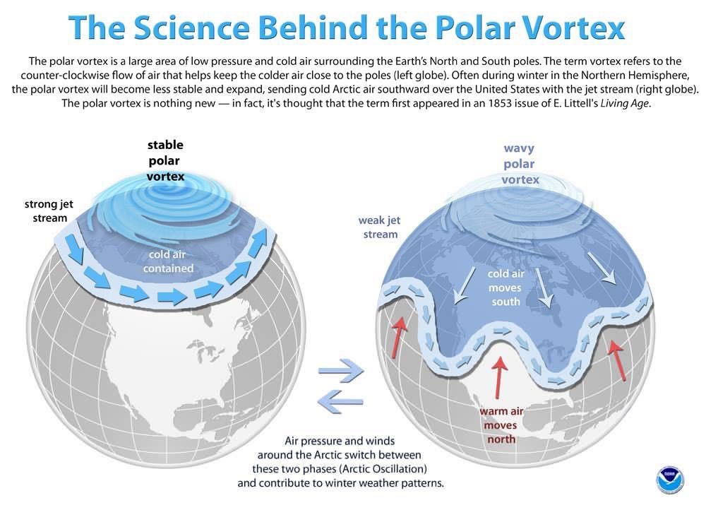
The polar vortex is an area of low pressure and cold air that circulates around the North and South poles. The vortex is present all year, but it strengthens and expands in the winter in the Northern Hemisphere, pushing cold air south with the jet stream, according to the National Weather Service. This year, two areas of high pressure are sending the cold air from Canada down into the eastern U.S., according to Fox Weather. The weather pattern could produce winter storms with the potential for snow to accumulate in major cities such as New York, Chicago, Boston, Philadelphia and Washington D.C., according to AccuWeather.
Lafayette, Louisiana saw more snow today than Philadelphia, NYC, Salt Lake City, Chicago, and Minneapolis have seen *ALL SEASON*
Upside down weather pic.twitter.com/KnEyDyrRF5
— Eric Fisher (@ericfisher) January 21, 2025
The weather pattern could prove disruptive and damaging, with the possibility for power grid damage, heavy snow across the Great Lakes and into the Northeast, and frozen pipes and water damage in poorly insulated or exposed homes in south-central and southeastern states, according to AccuWeather. Virginia, North Carolina, South Carolina, Georgia, Alabama and Florida could record their coldest January in many years if the Arctic outbreak reaches its full potential. “In an extreme scenario where the cold lingers past the middle of January,” Dan DePodwin, senior director of forecasting operations at AccuWeather, said in the article, “January 2025 could be the coldest since January 2014 in this region, which was 6 F [3.3 C] colder than the historical average.”
The southern polar vortex, having been displaced in July, may actually split in early August. pic.twitter.com/V28vAZzJFg
— Andrew Miskelly (@andrewmiskelly) July 31, 2024
POLAR VORTEX SPLITS
https://newscientist.com/antarctics-polar-vortex-could-be-about-to-split-in-two
https://seattletimes.com/polar-vortex-splitting-may-lead-to-weeks-of-wild-winter-weather
The polar vortex is splitting in two, which may lead to weeks of wild winter weather
by Andrew Freedman / Jan. 5, 2021
“A dramatic spike in temperatures is occurring at high altitudes above the North Pole, where the air is thin and typically frigid. Known as a sudden stratospheric warming event, experts say it’s likely to have potentially significant repercussions for winter weather across the Northern Hemisphere for weeks to possibly months. This unusually strong event may have profound influences on the weather in the United States and Europe, possibly increasing the potential for paralyzing snowstorms and punishing blasts of Arctic air, with the odds of the most severe cold outbreaks highest in Northern Europe. The United States is slightly more of a winter wild card for now, experts say, with individual winter storms tough to predict beyond a few days in advance.
Just like hundreds of other meteorologists today, I am speechless. ?❄️ #flwx pic.twitter.com/dGwL2eUNxU
— Christopher Pipkin (@ChrisPipkinWx) January 21, 2025
While occurring about 18 miles high in the sky and disconnected from the weather on the ground, stratospheric warming events can affect the polar vortex, which is a circulation of air around low pressure that acts as a repository for some of the coldest air on the planet. If the polar vortex is strong and stable, as it was last winter, that cold air will stay bottled up over the Arctic, and snow chances may be few and far between for regions such as the Mid-Atlantic and Northeast. But when the polar vortex weakens and wobbles off the pole, pieces of it can swirl southward, affecting the United States, Europe and Asia. And that’s exactly what’s begun to happen, due in large part to this stratospheric temperature spike.
Foot and a half deep snow drifts meets the Gulf of Mexico in Cameron Parish Louisiana. I can’t say I ever even imagined such a thing happening. Last time I was here at this beach was hours before Hurricane Laura devastated this coastline. #lawx #blizzard #snow pic.twitter.com/QZMGbqtAOG
— Brian Emfinger (@brianemfinger) January 21, 2025
To accurately forecast how winter weather may soon unfold in the United States and elsewhere, seasonal forecasters like Judah Cohen of Atmospheric and Environmental Research in Massachusetts are trying to figure out how the events in the stratosphere will ripple back downward into the troposphere, the layer of the atmosphere where most weather occurs. Stratospheric warming events are a known, but not guaranteed, trigger for knocking the polar vortex off balance, like flicking a spinning top, forcing it to spin more slowly and erratically. They are triggered by an upward flow of energy in the form of “large-scale atmospheric waves” from the lower atmosphere, according to Amy Butler, a research scientist at the National Oceanic and Atmospheric Administration’s Chemical Sciences Laboratory.
Biloxi Beach en Mississippi ?❄️?
? de Lauren Tedford #snow pic.twitter.com/hKbAvPhCeb— Davidd (@Noainmeteo) January 21, 2025
Now, the stratosphere stands poised to transfer energy via downward-moving atmospheric waves into the lower atmosphere, where it can help determine which areas get buried in blizzards while others see unusually mild conditions. Normally, winds in the stratosphere circulate from west to east around the North Pole, around an area of low pressure. But the rapid warming – on the order of 30 degrees Celsius in the past two weeks – taking place in the frigid, darkened Arctic is causing that low-pressure area to break down and the winds to slacken, Butler says. The winds are even poised to reverse, which can increase the chances of stratospheric weather affecting conditions in the lower atmosphere.
Snowy and icy French Quarter ? pic.twitter.com/ng1dx79WIQ
— Payton Malone WWL-TV (@paytonmalonewx) January 22, 2025
The polar vortex is synonymous with extreme cold and snow. Pieces of the vortex broke off and swirled southward during the infamous winter of 2013-14, when Chicago turned into “Chiberia” and heavy snow fell from Washington to Boston. Similar events occurred during the winter of 2009-10, which was D.C.’s snowiest on record. So the news that the bone-chilling lobes of ultracold air may soon be on the march again may be cause for concern for anyone worried about a harsh winter in the United States and Europe in particular.
It’s a Cat. 5 Snowicane on Lakeshore Drive on Lake Pontchartrain in New Orleans, LA! pic.twitter.com/RIVUEAC9HO
— Ed Piotrowski (@EdPiotrowski) January 21, 2025
But it’s quite a leap to go from the stratosphere to conditions at ground level, and Cohen, for example, argues that regardless of how impressive the stratospheric warming or polar vortex movement is, “No one is going to care until there is snow in people’s backyards.” Because this sudden stratospheric warming event is so intense, there’s a greater chance it will affect the polar vortex, but the precise connections between the stratosphere and troposphere are still not well understood. For example, a relatively strong stratospheric warming event last winter never knocked the polar vortex off-kilter, Cohen noted. Sudden stratospheric warming events happen about six times per decade on average, but this event is unusually intense.
Never change South Louisiana @spann pic.twitter.com/Q5Jgml9ldp
— Paul In The Heights ?? (@HeightsTiger) January 21, 2025
Cohen and other experts are predicting the stratospheric warming event and other conditions to result in a split polar vortex, with one center over Eurasia, and another vortex, known as a “sister vortex,” swirling elsewhere. Polar vortex splits are distinct from vortex displacements, which involve shifting the bulk of the vortex southward, away from the pole, and parking it over one unfortunate spot on the globe. Polar vortex splits that are initiated by events in Siberia tend to be more complicated, Cohen said, with fewer guarantees of major cold and snow in the Eastern United States. However, snow lovers have plenty of reasons to be optimistic.”
PREVIOUSLY

CATASTROPHE BONDS
https://spectrevision.net/2024/08/16/catastrophe-bonds/
FLASH FLOOD SEASON
https://spectrevision.net/2023/09/13/flash-flood-season/
ANTARCTICA WEATHER PORN
https://spectrevision.net/2007/10/26/spectrevision-presents-antarctica-weather-porn/
